Re-B ‘Caring for Our Water’
Norman Jackson
Norman Jackson
Our Ponds
The second strand of our project, led by Norman, is concerned with our wild water - the rain and what happens to it as it moves into and through the ground, gathers in ponds and lakes or travels along watercourses, drainage channels and brooks to the River Mole.
We have an environmental duty of care to limit pollution, to harvest and store our water and encourage it to soak into the ground and eventually find its way unpolluted to the aquifers and river.
Mapping our natural resources
To start, we wanted to better understand these surface water resources, so over the last few months the RE-B team has undertaken a survey of the ponds and lakes of the Betchworth and Buckland Parishes. Ponds and lakes were identified on 1:10,000 scale OS Maps printed at poster size. Remote sensing imagery was also used to verify and refine water-based features including Google Earth, Bing Landsat and LIDAR. Older OS Maps including the 1875 25” to 1 mile and 1890-1913 OS series maps. This allows for ancient ponds and waterways to be distinguished from modern ponds and enables a historical perspective to be gained on some of our waterways. Where possible water features were verified on the ground and a photographic database was constructed.
The full report is provided below It is in two parts: Part 1 contains an inventory of the ponds and lakes together with their location shown on OS Maps, while Part 2 provides a photographic database which can be developed as new ponds are added to the database or existing ponds are restored/regenerated. Not all of our ponds are accessible to the public, and we welcome photographs of ponds that are not yet on our database.
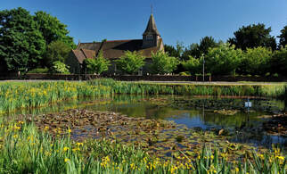
Many of our ponds are over 100 years old and but some ancient ponds, shown on the 1875 map, are no longer with us e.g. near Wellhouse Rd junction, Snowerhill Farm, on the north side Wellhouse Lane, Stroodgreen Farm and Wonham Manor. Naturally occurring ponds are often located in topographic depressions where the ground intersects the water table or at or near a spring line (e.g. Buckland Village pond - left).
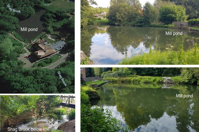
Other ponds have been created by damming streams, for example two dams along the Sloughs Brook, before it enters the River Mole have created two large ponds that run parallel to The Street in Betchworth. Further north, Slough Brook was dammed near the Red Lion Pub creating a pond that once stretched 300m NE along the line of the brook. Part of the dam was demolished in the 1970s and only a small shallow pond and wetland area remains. Similarly, in ancient (Saxon?) times, Shag Brook was dammed to create the mill pond at Wonham (right).
Buckland has several large lakes – the 50 acre Buckland Park Lake and smaller Taplow Lakes which now provide sport (commercial fishing, paddle boarding) and leisure facilities. The lakes were produced through the quarrying of high quality silica sands between 1955-1990. When quarrying ceased, lakes formed naturally in the depressions that were below the water table as the Lower Greensand is a natural aquifer. Watch our pond movie
Buckland has several large lakes – the 50 acre Buckland Park Lake and smaller Taplow Lakes which now provide sport (commercial fishing, paddle boarding) and leisure facilities. The lakes were produced through the quarrying of high quality silica sands between 1955-1990. When quarrying ceased, lakes formed naturally in the depressions that were below the water table as the Lower Greensand is a natural aquifer. Watch our pond movie
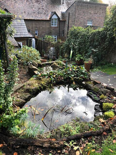
Garden Ponds
Our caring for our natural water project is entering its next stage when we want to encourage the restoration of ponds that have been neglected and the creation of new ponds.
Creating, maintaining or restoring a pond, however small, is the most useful things we can do to create new habitats for plants and animals. We want to find out just how many residents of Betchworth already have a pond in their garden. We will then set out to encourage the regeneration of existing ponds and the creation of new ponds. Our intention is to help anyone who would like to create a small pond.
We will be hosting a zoom meeting in April to consider how best we can achieve this goal. If you would like to be involved in any of the activities associated with our Caring for Our Water Project, please get in touch with Norman – [email protected] or Deb - [email protected]k.
